Most people don’t spend their weekends researching land surveys. So when the need suddenly comes up — a closing in Brownsville, a construction project near the Rio Grande Valley, a boundary dispute on family land — it’s natural to feel a little lost. Where do you even start? Right here.
This guide walks you through the full process of booking land surveying services: when a survey is actually required, what documents to gather, how to find a trustworthy surveying company, and what to expect once everything’s scheduled.
Whether you’re a first-time homebuyer trying to make sense of plat maps or a seasoned developer managing multiple parcels, knowing how to schedule land surveying services the right way can save you time, money, and a whole lot of frustration. We’ve seen projects stall for weeks simply because someone waited too long or didn’t have the right paperwork ready. On the flip side, we’ve watched well-prepared clients breeze through the process in just a few days. The difference almost always comes down to understanding the steps before you pick up the phone. And that’s exactly what we’re here to help with.
When It’s Time to Invest in a Land Survey
Not every property situation calls for a survey at the same point in the timeline, so understanding your trigger is the first step.
If you’re buying or selling property, your lender or title company will likely require a current survey before closing. Mortgage surveys and ALTA/NSPS land title surveys are among the most commonly requested, and waiting until the last minute to schedule one can push back your closing date.
For builders and developers, surveys typically need to happen before design work begins. A topographic survey, for example, maps the terrain, drainage patterns, and existing structures on a site so engineers and architects can plan accurately. Foundation surveys come into play just before concrete is poured.
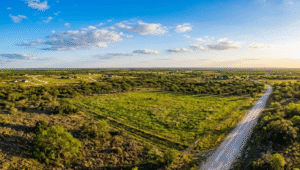
Then there are boundary disputes or property improvements. If you’re installing a fence, adding a structure, or simply want to confirm where your property lines fall, a boundary survey provides that clarity. Landowners across South Texas often find this especially important on larger rural parcels or older lots where original markers have shifted or disappeared.
The common thread here is timing. In almost every case, scheduling your survey early in the process prevents delays down the road.
What To Know Before You Book

Before you pick up the phone or fill out a quote request, it helps to gather a few things.
Your property’s legal description is the most important piece. This is typically found on your deed or title commitment. If you’re in the middle of a real estate transaction, your title company or real estate agent should be able to provide it.
You’ll also want to know:
- The type of survey you need (boundary, mortgage, topographic, ALTA/NSPS, etc.)
- Any deadlines tied to your closing, permitting, or construction schedule
- Whether there are known issues such as encroachments, easements, or prior disputes
- Access details if the property is gated, rural, or otherwise difficult to reach
If you’re unsure which survey type fits your situation, that’s perfectly fine. A good surveying company will help you figure that out during the initial conversation. You can explore the full range of services we offer to get a sense of what’s available before reaching out.
Having this information ready doesn’t just speed things up. It also helps the surveyor give you a more accurate quote and timeline from the start.
How To Choose The Right Surveying Company

Not all surveying firms operate the same way, and the cheapest option isn’t always the best fit. Here’s what to look for when choosing a company to schedule land surveying services with.
Credentials And Licensing
In Texas, land surveys must be performed or supervised by a Registered Professional Land Surveyor (RPLS). Always confirm that the company you’re considering employs a certified surveyor. At Southpoint Geodetics, LLC, our founder Michael Wood is a Registered Professional Land Surveyor licensed in both Texas and Mississippi, and our team uses state of the art GPS along with conventional surveying techniques to ensure precision.
Local Experience
South Texas has its own set of challenges, from older Spanish land grants and irregular lot configurations to flood zones along the Rio Grande Valley. A surveying company with deep roots in the region will understand these nuances and can navigate local requirements more efficiently.
Responsiveness
Pay attention to how quickly a company responds to your initial inquiry. If it takes days to hear back on a quote, that pace may carry over into the actual survey work. Timely communication matters, especially when your project is on a deadline.
Range Of Services
Some firms specialize in a single survey type, while others handle everything from ALTA/NSPS surveys to engineering and as-built surveys. Working with a full service company means you won’t need to coordinate with multiple providers if your project scope changes.
What To Expect After You Schedule Your Survey
Once you’ve booked your survey, the process typically unfolds in a few clear stages.
Document Review
First, the surveying team will review your documents and any existing records for the property. This includes prior surveys, plat maps, and legal descriptions. For properties in areas like Brownsville or Harlingen, the surveyor may also check county records for easements, right of way information, or flood zone data.
Fieldwork
Next, a crew will visit your property to take measurements, set or locate boundary markers, and document features relevant to the survey type. Depending on the size and complexity of the parcel, this could take anywhere from a few hours to a full day.
Final Deliverable
After the field visit, the surveyor prepares the final deliverable, whether that’s a plat, a certified survey map, or a detailed report. Turnaround times vary, but most residential surveys in South Texas are completed within one to two weeks from the field visit.
You can find additional resources in our blog that explain specific survey types in more detail, including what the final documents look like and how they’re used in real estate closings and construction permitting.
Tips For Avoiding Delays In The Surveying Process

Delays happen, but many of them are preventable. Here are a few practical ways to keep your survey on track.
Book Early
During peak real estate and construction seasons, surveying companies see higher demand. If you know a survey will be needed, don’t wait until you’re two weeks from closing to schedule it.
Clear The Property
Overgrown brush, locked gates, or aggressive dogs can prevent a survey crew from completing their work. Make sure the crew has reasonable access to the property, especially along boundary lines.
Communicate Deadlines Clearly
Let the surveying company know about any hard deadlines up front. Whether it’s a closing date, a permit submission window, or a construction start date, this helps the team prioritize your project appropriately.
Respond Promptly To Requests
If the surveyor asks for additional documents or information, getting those back quickly prevents unnecessary back and forth.
Coordinate With Your Other Professionals
Let your real estate agent, title company, or lender know when your survey is scheduled so everyone stays on the same page.
Conclusion

Knowing how to schedule land surveying services doesn’t require any specialized knowledge. It comes down to understanding when a survey is needed, preparing your documents, choosing a qualified local team, and staying ahead of potential delays.
At Southpoint Geodetics, LLC, we work with homebuyers, sellers, builders, and landowners across the Rio Grande Valley to deliver accurate surveys on time and without unnecessary complications. Whether you need a boundary survey for a property sale or a topographic survey ahead of construction, our team is ready to help.
If you have questions about your specific situation, contact us to discuss your property. We’re happy to walk you through the process and help you take the next step with confidence.
When should I schedule land surveying services?
You should schedule land surveying services as early as possible in your project timeline. If you’re buying or selling property, book before your closing deadline. For construction, schedule before design work begins. Early scheduling prevents costly delays, especially during peak real estate and construction seasons in South Texas.
What documents do I need before booking a land survey?
The most important document is your property’s legal description, typically found on your deed or title commitment. You should also know the type of survey needed, any project deadlines, known issues like easements or encroachments, and property access details. Having these ready helps the surveyor provide an accurate quote and timeline.
How long does a land survey take to complete?
Most residential surveys in South Texas are completed within one to two weeks from the field visit. Fieldwork itself can take a few hours to a full day depending on parcel size and complexity. Turnaround times may vary based on demand and the type of survey requested.
What types of land surveys does Southpoint Geodetics, LLC offer?
Southpoint Geodetics, LLC offers a comprehensive range of services including boundary surveys, ALTA/NSPS land title surveys, topographic surveys, mortgage surveys, engineering surveys, foundation surveys, as-built surveys, farm and ranch surveys, digital terrain modeling, and utility mapping. Any project, any size—their team can help.
How do I choose the right land surveying company in Texas?
Look for a company that employs a Registered Professional Land Surveyor (RPLS), which is required by Texas law. Prioritize local experience, quick response times, and a full range of services. A locally rooted firm like Southpoint Geodetics, LLC understands regional challenges such as Spanish land grants and Rio Grande Valley flood zones.
What is the difference between a boundary survey and an ALTA/NSPS survey?
A boundary survey establishes property lines by locating or setting corner markers based on the legal description, deed, and prior survey records. It’s commonly used for fences, property disputes, and smaller real estate transactions. An ALTA/NSPS Land Title Survey meets strict national standards set by the American Land Title Association and the National Society of Professional Surveyors. It goes beyond a boundary survey by documenting property lines, improvements, easements, utilities, access points, and other conditions that could affect title or use. It is most commonly required by lenders and title insurance companies in commercial real estate transactions, refinances, and development projects.