Realtors across Harlingen and the Rio Grande Valley know that a stalled closing can unravel weeks of work. One of the most preventable causes of delays is a boundary dispute or title issue that surfaces late in the transaction. When you book professional land surveying services at the start of the listing process, rather than scrambling at the end, you give everyone involved a clear picture of exactly what is being bought and sold. Southpoint Geodetics works with Valley realtors, developers, and buyers to resolve these questions before they become problems.
Why Realtors in the Valley Should Prioritize Surveys at Listing Time
Starting the survey process at listing, not at closing, protects your timeline and your commission. A boundary survey completed before offers come in means you can answer buyer questions with documented facts instead of estimates.
Harlingen and surrounding areas like Weslaco, McAllen, and San Benito have a significant share of older properties with recorded plats that do not reflect decades of fence lines, outbuildings, or informal property splits. Identifying those discrepancies early keeps them from appearing on a title commitment and delaying your closing date.
What a Boundary Survey Actually Shows
A boundary survey establishes the legal corners and lines of a parcel based on recorded deeds, plats, and field measurements. It tells you exactly where the property begins and ends.
Lenders and title companies commonly request a boundary survey in residential transactions, though specific requirements vary by lender and transaction type. The survey confirms that structures on the property sit within the legal boundary and that no neighboring improvements have encroached. For older Rio Grande Valley homes and rural acreage, this clarity is especially valuable.

The Role of ALTA/NSPS Surveys in Commercial Deals
Commercial transactions in the Valley, including retail, industrial, and mixed-use properties, frequently require an ALTA/NSPS Land Title Survey. This is a more detailed product that meets national standards set jointly by the American Land Title Association and the National Society of Professional Surveyors.
An ALTA survey goes beyond boundary lines. It documents easements, rights-of-way, encroachments, and access issues in a format that title insurers and lenders expect. Booking this survey early in a commercial listing gives your client’s attorney and lender time to review the findings without compressing the closing schedule.
How Topographic Surveys Support Development Listings
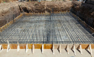
If you are listing a tract for development, a topographic survey is often the first deliverable a buyer’s engineer will request. It maps the elevation and contours of the land so engineers can plan drainage, grading, and infrastructure.
Listing a development tract without topographic data puts you in the position of waiting on the buyer’s team to order and complete their own survey. Having that data ready at listing can strengthen your offering and help accelerate the due diligence phase.
Title Commitments, Exceptions, and What Surveyors Help Clarify
When a title company issues a commitment, it often includes survey exceptions, which are items the title insurer excludes from coverage because boundary or encroachment information has not been verified. A current survey can remove or reduce those exceptions.
Buyers and their lenders notice survey exceptions. They create questions, negotiations, and sometimes requests for price reductions. A certified survey produced by a licensed Registered Public Land Surveyor gives the title company what it needs to close those exceptions and move the transaction forward cleanly.

Working With an RPLS in Texas: What the License Means
In Texas, only a Registered Public Land Surveyor can certify a boundary or title survey for legal and real estate purposes. The RPLS credential requires passing state examinations and meeting experience requirements set by the Texas Board of Professional Land Surveying.
Southpoint Geodetics was founded by Michael Wood, RPLS, licensed in both Texas and Mississippi. When you order a survey from us, a licensed professional is responsible for every measurement and certification on that document.
Common Survey Issues Found on Harlingen Properties
Fence lines that do not match deed boundaries are among the most common issues found on residential properties in Harlingen and the surrounding Valley. They are often the result of informal agreements between neighbors that were never recorded.
Utility easements running through a parcel in unexpected locations are another frequent finding. These can affect where a buyer plans to build or expand. Catching either issue before a contract is signed gives the seller options, including corrective action or adjusted pricing, without the pressure of a closing deadline.

How to Book Professional Land Surveying Services With Southpoint Geodetics
Booking land surveying services with Southpoint Geodetics starts with a conversation about the property and what the transaction requires. You can reach Michael Wood directly at (956) 368-5074 or submit project details through our contact form.
We serve Harlingen, McAllen, Weslaco, San Benito, Edinburg, Brownsville, and the broader Rio Grande Valley. Whether you need a residential boundary survey, an ALTA survey for a commercial closing, or a topographic survey for a development parcel, we can scope the right product for your timeline.
Book Professional Land Surveying Services Before the Listing Goes Live
Realtors who arrange surveys before a listing goes active are better positioned to close with fewer interruptions. A survey ordered early answers buyer questions, helps satisfy lender and title company requirements, and can remove title exceptions before they slow you down.
Southpoint Geodetics is a locally owned firm serving the Rio Grande Valley. Request a quote today and give your next transaction a solid foundation from the start.
What should I look for when booking a professional land surveying service?
Look for a firm with a licensed Registered Public Land Surveyor on staff who will certify the final product. Verify that the surveyor holds an active Texas RPLS license and carries errors and omissions insurance. Experience with the specific property type and local deed records also reduces the risk of delays or corrections after the survey is delivered.
How much does it cost to hire a professional land surveyor?
Survey costs vary based on property size, terrain, available recorded documents, and the type of survey required. A residential boundary survey in the Rio Grande Valley is generally less involved, and less costly, than an ALTA survey for a commercial parcel. The best way to get an accurate figure is to contact Southpoint Geodetics directly at (956) 368-5074 or submit a quote request with your property details.
How long does a professional land survey take to complete?
Completion time depends on the survey type, property complexity, and current workload. Residential boundary surveys are generally completed faster than ALTA or topographic surveys. Ordering early in a real estate transaction, rather than waiting until after a contract is signed, gives the surveying team adequate time and reduces pressure on your closing date.
What types of land surveys do professional surveyors offer?
Professional surveyors offer boundary surveys, ALTA/NSPS land title surveys, topographic surveys, subdivision platting, and construction staking, among others. The right type depends on the transaction. Residential sales often require a boundary survey, commercial deals typically require an ALTA survey, and development tracts may need topographic data. A licensed RPLS can help identify the correct product for your specific situation.
Do I need a professional land survey before buying or selling property?
A professional land survey is not always legally required to buy or sell property in Texas, but lenders and title companies frequently require one to close. Even when not required, a current boundary survey helps protect buyers from unknowingly purchasing property with encroachments, disputed lines, or unrecorded easements. Sellers benefit too, as a clean survey can reduce buyer objections and support a smoother closing process.