If you own property anywhere across South Texas, there’s a good chance a land survey will land on your to-do list sooner than you expect. Maybe you’re closing on a home in Brownsville, planning to fence a lot, or settling a question about where your land actually ends. At Southpoint Geodetics, LLC, we help property owners answer those questions with accuracy through dependable land surveying services built on decades of regional experience.
Quick Answer: Licensed professional land surveying services are state-regulated measurements and mappings performed by a Registered Professional Land Surveyor (RPLS) that legally establish boundaries, locate improvements, identify easements, and produce sealed documents accepted by lenders, title companies, courts, and government agencies. Common types include boundary surveys, ALTA/NSPS land title surveys, topographic surveys, construction staking, and elevation certificates.
Land surveying is the science of measuring and mapping land’s physical and legal characteristics. Licensed surveyors use specialized equipment, legal research, and professional judgment to establish boundaries and produce records recognized by lenders, courts, and government agencies. This guide covers what licensed land surveying services include, when you need them, and how to choose the right team for your 2026 project.
What Land Surveying Services Actually Include

When most people picture a survey, they imagine someone standing behind a tripod near the road. That’s part of it, but licensed professional land surveying services cover a lot more ground than a few measurements.
A licensed surveyor establishes and documents the legal boundaries of a parcel, locates physical features and improvements, and records the data in a way that holds up for lenders, title companies, and courts. The work blends field measurements with research into recorded documents, deeds, and prior surveys.
At Southpoint Geodetics, LLC, we combine advanced GPS positioning with conventional surveying techniques to deliver dependable results. Depending on your project, our land surveying services may include:
-
Boundary and acreage surveys
-
Topographic surveys showing contours and physical features
-
ALTA/NSPS Land Title Surveys
-
Construction staking and as-built surveys
-
Easement and right-of-way documentation
Each service answers a different question, but they all share the same goal: accurate information you can trust before you build, buy, or sell.
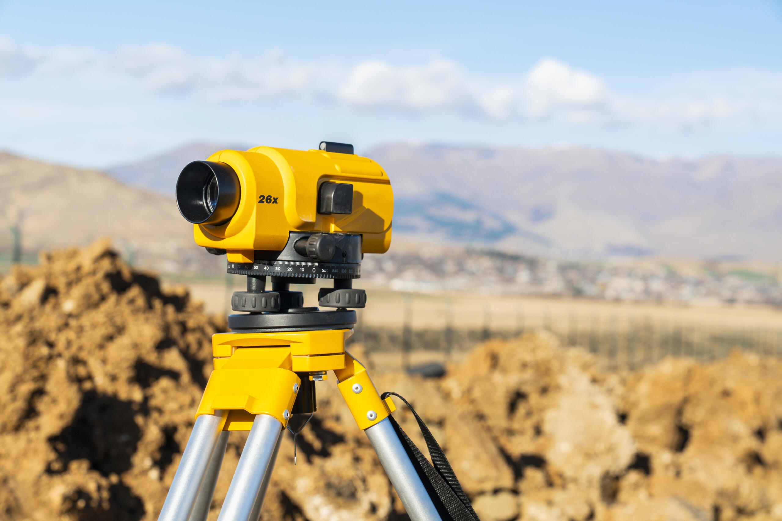
The Equipment and Technology Behind Accurate Results
Modern land surveying relies on far more than a tripod and a tape measure. Today’s licensed surveyors use a combination of GPS/GNSS receivers, total stations, and — on select projects requiring detailed three-dimensional documentation — terrestrial laser scanning technology to capture precise measurements across even the most challenging South Texas terrain.
At Southpoint Geodetics, LLC, our surveyors work with professional-grade equipment calibrated to meet Texas state standards. Whether we’re setting geodetic control points for a large development or performing a boundary survey on a single residential lot, the right tools ensure accuracy at every stage — backed by field data that holds up in court, at the closing table, and throughout the design and construction process.
Common Types of Land Surveying Services and When You Need Them
Not every property situation calls for the same survey. Knowing which one fits your project saves time and avoids paying for work you don’t need.
Boundary and Lot Surveys
A boundary survey establishes the exact limits of your parcel using its legal description. It typically involves setting or restoring monuments at the corners and along the property lines.
This is the survey people reach for most often. Planning a new fence? Building an addition? Wondering whether your neighbor’s shed crossed the line? A boundary survey gives you a clear, documented answer. Whether your property is a single city lot or thousands of acres, you learn precisely where your land begins and ends, backed by field evidence and recorded records.
Surveys for Real Estate Closings
Many real estate transactions in South Texas require a survey before the deal can close. Lenders and title companies often ask for a boundary survey to confirm that structures, improvements, and boundaries match the legal description on file.
For more involved transactions, an ALTA/NSPS Land Title Survey provides a detailed picture of existing improvements and combines elements of boundary and topographic work. If you’re handling an easement question that affects closing, you may also need a dedicated easement survey to clearly define access and utility rights.
If you’re unsure which survey your lender requires, your real estate agent or mortgage professional can usually point you in the right direction, and we’re glad to clarify the details too.
Why Hiring a Licensed Surveyor Matters
It’s tempting to think a tape measure and an old plat are enough. They aren’t. Property lines carry real legal weight, and a guess can turn into an expensive dispute.
A licensed surveyor is held to state standards and professional accountability. In Texas, that means the work is performed or supervised by a Registered Professional Land Surveyor licensed by the Texas Board of Professional Land Surveying (TBPLS), whose seal stands behind the results. That credential is what makes a survey acceptable to lenders, title companies, and county records.
The value goes beyond paperwork. Accurate surveys prevent the kinds of conflicts that delay closings, stall construction, or strain relationships with neighbors. There’s also local knowledge to consider. South Texas land comes with its own realities, from flood-prone areas near the Rio Grande Valley to older parcels with imperfect records. A surveyor who understands the region reads those situations more accurately.
What to Expect: Timeline, Cost, and the Survey Process

Two questions come up more than any others: how much will it cost, and how long will it take? Both depend on your property and project.
Cost is shaped by the size and shape of the parcel, terrain, the type of survey, the quality of existing records, and how much research is required. A straightforward residential lot is far simpler than a large acreage tract with tangled historical deeds. Timeline works the same way — some surveys wrap up within days, while complex projects take longer. Weather and access to the property can also affect the schedule.
Here’s what the process generally looks like:
-
Initial consultation — Your needs and the property details are reviewed to determine the right survey type
-
Records research — Deeds, plats, and prior surveys are pulled and analyzed before fieldwork begins
-
Field measurements — A crew visits the property to collect data using GPS and conventional equipment
-
Data analysis and drafting — Field data is processed and the survey documents are prepared
-
Delivery — You receive a sealed survey ready for your lender, title company, builder, or county records
Starting early is the single best thing you can do. It gives everyone time to catch boundary conflicts or easement issues before they affect your closing or break-ground date.
How to Choose the Right Surveyor in South Texas
Picking a surveyor isn’t only about price. The right partner protects one of your largest investments, so a few things are worth checking before you commit.
Start with licensing. Confirm the work is backed by a Registered Professional Land Surveyor licensed in Texas by the TBPLS. Then look at experience with your type of property, whether that’s a residential lot in Brownsville, a farm and ranch tract, or a commercial development.
A few practical questions to ask:
-
Are you licensed in Texas, and who seals the survey?
-
Have you handled properties like mine in South Texas?
-
What equipment and methods do you use for accuracy?
-
How do you communicate timelines and findings?
Responsiveness matters too. A team that answers questions clearly and keeps your project moving saves you headaches down the line. As a locally owned company serving the Rio Grande Valley and all of South Texas, we pride ourselves on accurate surveys and dependable communication.
Moving Forward With Confidence

By now you understand what licensed professional land surveying services cover, which surveys fit common property situations, and why a licensed surveyor is worth it. The next step is simple. When you’re ready to define your boundaries or prepare for a project, contact us to discuss your property and what you need.
What exactly is included in licensed professional land surveying services?
Licensed professional land surveying services establish and document legal property boundaries, locate physical features and improvements, and record data for lenders and title companies. Services typically include boundary surveys, topographic surveys, ALTA/NSPS surveys, construction staking, and easement documentation using advanced GPS and conventional techniques.
Is it possible to get land surveyed for free?
A professional licensed survey isn’t free — it requires skilled surveyors, calibrated equipment, records research, and a licensed seal. That said, county appraisal districts offer free digitized plat maps and prior survey records for background research, though these don’t replace a current licensed survey. If you’re buying a home, your title company may accept a recent survey already on file. For most transactions, investing in an accurate survey upfront is far less expensive than resolving boundary disputes, permit rejections, or title issues later.
How much do land surveying services cost in South Texas?
The cost depends on parcel size, terrain, survey type, and record quality. A residential lot is simpler and more affordable than a large acreage tract with complex historical deeds. Timeline varies the same way. The most reliable estimate comes from a quote based on your specific property.
When do I need a boundary survey for my property in South Texas?
You need a boundary survey when planning a fence, building an addition, settling property line disputes, or before buying or selling property. A boundary survey establishes the exact limits of your parcel using its legal description and sets monuments at corners and along property lines.
Why should I hire a licensed professional surveyor instead of doing it myself?
A licensed surveyor is held to state standards and professional accountability. Their Registered Professional Land Surveyor seal makes surveys acceptable to lenders, title companies, and courts. Accurate surveys prevent costly disputes, delays, and neighborhood conflicts — protecting one of your largest investments.
What is the difference between a boundary survey and an ALTA/NSPS Land Title Survey?
A boundary survey establishes property line limits. An ALTA/NSPS survey is more comprehensive, incorporating elements of boundary and topographic work to provide a detailed picture of existing improvements and physical features for complex transactions.
Do I need a survey before closing on a home in South Texas?
Many real estate transactions require a survey before closing. Lenders and title companies ask for surveys to confirm that structures and boundaries match the legal description. For easement questions affecting closing, a dedicated easement survey may also be needed. Your lender or real estate agent can advise on specific requirements.