What is included in professional land survey services? The answer depends on the property, the type of survey, and what the information will be used for. In most cases, professional surveying combines records research, field measurements, boundary analysis, and clear documentation.
Buyers, sellers, landowners, builders, developers, and project teams use this information to better understand a parcel before making decisions involving property boundaries, improvements, design, construction, or future use.
Southpoint Geodetics, LLC provides professional land surveying services throughout Brownsville, Cameron County, the Rio Grande Valley, and surrounding South Texas communities. From established residential lots to rural acreage and active development sites, each survey begins with understanding the property and the purpose of the work.
What a Professional Land Survey Confirms

A professional land survey can establish or document property boundaries and identify improvements, easements, monuments, elevations, and other features relevant to the requested scope.
Surveyors do not automatically treat a fence, driveway, wall, or old marker as proof of a legal boundary. These visible features may provide useful evidence, but they must be evaluated together with deeds, plats, monuments, adjoining property information, and field measurements.
This becomes especially important when site conditions do not match the property records. A fence may sit away from the surveyed boundary, an improvement may be close to an easement, or adjoining records may contain information that requires closer review.
Professional surveying in Texas is regulated by the Texas Board of Professional Engineers and Land Surveyors, which oversees registration requirements and professional practice standards for land surveyors.
Questions involving ownership rights, title interpretation, or legal disputes may still require guidance from an attorney or title professional. The surveyor’s role is to document relevant evidence and professional findings within the agreed scope.
Need help determining which type of survey fits your property? Explore Southpoint Geodetics’ professional land surveying services.
Property Records, Deeds, Plats, and Easement Research

Professional surveying often begins before a field crew arrives. Depending on the assignment, the surveyor may review the current deed and legal description, subdivision plats, previous surveys, adjoining property records, easement documents, and other available public records.
These materials help establish how the parcel was created and what evidence should be investigated in the field. Legal descriptions may include lot and block information, bearings and distances, acreage, monuments, or older survey calls.
For some Texas properties, historical maps, land grants, and survey records may also provide useful context. The Texas General Land Office maintains extensive collections of Texas land records, maps, and historical documents used by surveyors, researchers, attorneys, and other professionals.
On larger or older South Texas tracts, some descriptions may rely on historical evidence that has changed or disappeared over time. A missing corner marker does not erase the boundary, but it can mean additional research and professional analysis are required.
Recorded easements can also be important. Utility, drainage, access, pipeline, and other easements may affect how portions of a property can be used. When included within the survey scope, applicable easement information can be compared with conditions observed on the site.
Want to better understand common property and surveying questions? Explore Southpoint’s land surveying resources and articles.
On-Site Measurements, Boundary Evidence, and Improvements

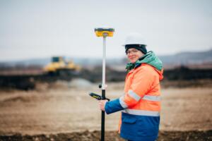
Fieldwork is the most visible part of professional surveying, but measurements alone do not determine a boundary. Survey crews may use total stations, levels, satellite positioning systems, and other professional equipment to collect precise data across the property.
Crews may search for iron rods, pipes, concrete monuments, fence corners, or other physical evidence related to the property description. Depending on the survey type, they may also locate buildings, driveways, walls, sidewalks, utilities, drainage features, pavement, trees, or other improvements.
After fieldwork, the measurements are compared with deeds, plats, monuments, and other available evidence. If a fence does not follow the record boundary or a structure sits close to an easement, the surveyor evaluates those conditions before preparing the final survey.
Common Types of Land Surveys and When Each Is Needed
Professional land survey services are not one-size-fits-all. The appropriate survey depends on whether the client needs to confirm boundaries, document terrain, support a commercial transaction, plan construction, or record completed improvements.
Boundary surveys establish or retrace parcel boundaries using legal descriptions, records, monuments, measurements, and physical evidence. They may be useful before purchasing land, installing a fence, planning improvements near a property line, or addressing boundary questions.
Topographic surveys document terrain, elevations, and selected natural and constructed features. Engineers, architects, builders, and developers may use this information for grading, drainage analysis, site design, and development planning.
ALTA/NSPS Land Title Surveys follow national standards and are commonly associated with commercial real estate, lending, and title matters. Depending on the transaction, the scope may also include optional Table A items.
Farm and ranch surveys may address larger acreage, fencing, access, easements, improvements, and boundary conditions across agricultural, recreational, or undeveloped land.
Engineering and construction surveys support design, layout, monitoring, infrastructure, and other project needs. As-built surveys document specified improvements after construction for review, records, compliance, or project closeout.
For larger development projects, learn how land surveying can support a project from due diligence through construction.
Survey Deliverables: Maps, Markers, Certifications, and Findings

One of the most common deliverables is a signed and sealed survey plat or map prepared under the responsible charge of a Texas Registered Professional Land Surveyor.
Depending on the scope, the survey may show property boundaries, dimensions, found or set monuments, improvements, easements, notes, certifications, and other relevant site conditions. Property corner monuments may also be located or set when appropriate to the assignment and applicable requirements.
The completed survey document remains important even when physical markers are present. A single monument does not explain the entire parcel. The survey map shows how boundary points relate to one another and provides the dimensions, notes, and supporting information needed to understand the property as a whole.
Some assignments may also include legal descriptions, coordinates, elevation information, reports, digital files, or other project-specific deliverables. The intended use should be discussed before work begins because a homeowner confirming a property boundary may need something very different from an engineer preparing site plans or a commercial buyer completing a detailed transaction.
Survey findings should also be reviewed carefully. An apparent encroachment, conflicting record call, or easement does not automatically create a legal dispute, but it may identify a condition that deserves additional review.
Costs, Timelines, and How to Prepare for Surveying Services
Survey cost and turnaround time depend on the work required, not simply the acreage. A smaller residential lot with conflicting records, missing monuments, or restricted access may require more effort than a larger tract with clear documentation and strong boundary evidence.
Factors that may affect pricing and scheduling include:
- Property size, shape, terrain, and vegetation
- Availability and quality of deeds, plats, and previous surveys
- Existing monuments and boundary evidence
- Number of adjoining parcels requiring research
- Property access and site conditions
- Type of survey and requested deliverables
- Boundary discrepancies or conflicting records
- Travel and project coordination requirements
South Texas conditions can also affect fieldwork. Dense vegetation, standing water after heavy rain, difficult access, active construction, or large rural tracts may increase the time needed to collect reliable data.
Ordering early helps reduce pressure on a real estate closing, design schedule, or construction start date. Clients can also help by providing the current deed, legal description, prior survey, subdivision plat, title commitment, site plans, and relevant easement information when available.
It is equally important to explain why the survey is needed. A property owner preparing to replace a fence has different information needs from an engineer designing drainage improvements or an investor evaluating a commercial tract. Providing access instructions and notifying the surveyor about locked gates, pets, hazards, or other site conditions can also help fieldwork proceed more efficiently.
Conclusion

Professional land survey services bring together property records, field measurements, physical evidence, professional analysis, and clear documentation to create a more dependable picture of a property.
Understanding what is included can help buyers, landowners, builders, developers, and project teams choose an appropriate survey, prepare for fieldwork, understand the final deliverables, and plan more realistically for cost and timing.
Southpoint Geodetics, LLC provides professional surveying services for residential, commercial, rural, and development properties throughout Brownsville, Cameron County, the Rio Grande Valley, and surrounding South Texas communities.
Ready to discuss your property or project? Contact Southpoint Geodetics to review your survey needs, intended use, and expected deliverables.
Frequently Asked Questions About Professional Land Survey Service
What Is Included in Professional Land Survey Services?
Depending on the scope, services may include property records research, field measurements, boundary analysis, evaluation of physical evidence, and preparation of a signed survey plat or other documentation.
Why Is Property Records and Easement Research Important?
Deeds, plats, previous surveys, easements, and adjoining property records help the surveyor understand how a parcel was created and how recorded information relates to evidence found in the field.
What Types of Land Surveys Are Commonly Offered?
Common services include boundary, topographic, ALTA/NSPS, farm and ranch, engineering, construction, and as-built surveys. The appropriate type depends on the property and intended use.
How Do Surveyors Confirm Property Boundaries?
Surveyors evaluate legal descriptions, deeds, plats, monuments, adjoining property information, physical evidence, and field measurements before reaching a professional boundary conclusion.
How Long Does a Professional Land Survey Take?
Timing varies based on property size, available records, boundary complexity, terrain, vegetation, access, weather, monumentation, survey type, and requested deliverables.
What Deliverables Can I Expect?
A signed survey plat or map is a common deliverable. Depending on the agreed scope, clients may also receive monuments, legal descriptions, coordinates, elevation information, reports, digital files, or other specialized data.