Most people don’t think about a land survey until something goes wrong — a fence built two feet over a property line, a title company flagging an issue days before closing, or a permit application bouncing back. By that point, you’re scrambling. Knowing how to book land surveying services before problems surface puts you in control of the timeline, the budget, and the outcome.
At Southpoint Geodetics, LLC, we see this pattern play out across the Rio Grande Valley every week. This guide breaks down exactly when to schedule a survey, how to choose the right surveyor, and what to expect once the process is underway — so you’re never the one caught off guard.
When You Need A Land Survey
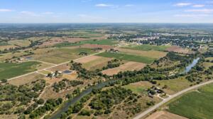
Not every property situation calls for a survey, but more do than most people realize. Here are the most common scenarios where booking a land survey is either required or strongly recommended:
- Buying or selling property. Mortgage lenders and title companies frequently require a survey before closing. A mortgage survey confirms boundaries and maps improvements so there’s no ambiguity about what’s being financed.
- New construction or additions. Before pouring a foundation, you need to verify setbacks, easements, and exact lot lines. A foundation survey or engineering survey ensures your project is positioned correctly from day one.
- Boundary disputes. If you and a neighbor disagree about where one property ends and another begins, a boundary survey provides the legal documentation to resolve it.
- Subdividing or developing land. Splitting acreage, rezoning, or planning a commercial project all require accurate survey data.
- Title insurance and ALTA/NSPS requirements. Commercial transactions and lender requirements often call for an ALTA/NSPS Land Title Survey, which combines boundary, topographic, and mortgage survey elements into one comprehensive document.
If you’re unsure whether your situation requires a survey, it’s worth asking early. Waiting until a title company or lender flags the need can add unnecessary delays to your timeline. You can browse our blog for related topics that break down each survey type in more detail.
What To Look For In A Land Surveyor

Choosing a surveyor isn’t like picking a contractor for a kitchen remodel. The results of a land survey carry legal weight, so credentials and local experience matter.
Licensing And Credentials
In Texas, a land surveyor must be a Registered Professional Land Surveyor (RPLS). This license confirms they’ve met the state’s education, experience, and examination requirements. Always verify that your surveyor holds an active RPLS license before booking.
Local Knowledge
South Texas has its own quirks when it comes to land records, flood zones, and property descriptions. A surveyor who knows the Rio Grande Valley understands the terrain, local municipal requirements, and how to navigate older Spanish land grants or irregular lot descriptions that are common in areas like Cameron and Hidalgo counties. That local familiarity translates into fewer surprises and faster turnaround.
Equipment And Methodology
Modern surveying relies on a combination of GPS technology and conventional measurement techniques. Ask whether the firm uses current equipment and whether they can handle the specific type of survey you need, whether that’s a topographic survey for a construction project or a simple lot boundary survey for a home purchase.
Responsiveness
Timelines matter. A surveyor who takes two weeks to return a phone call probably won’t deliver your survey on schedule either. Look for firms that communicate clearly and commit to realistic deadlines.
How To Book Your Land Survey

Once you’ve identified a qualified surveyor, booking the service is more straightforward than most people expect. Here’s how the process typically works:
- Gather your documents. Before reaching out, pull together whatever property information you have. This might include your deed, a previous survey (if one exists), the legal description of the property, and any relevant title documents. Having these ready speeds up the quoting process.
- Request a quote. Contact the surveying firm and describe what you need. Be specific about the type of survey, the size of the property, and your timeline. For example, if your lender requires a mortgage survey before a closing date three weeks out, say so upfront.
- Review the scope and cost. The surveyor should provide a clear explanation of what the survey will include, how long it will take, and what it will cost. Pricing depends on the survey type, property size, terrain, and whether additional research into historical records is needed. Don’t hesitate to ask questions.
- Schedule the fieldwork. Once you agree on scope and pricing, the surveyor will schedule a date for the field crew to visit your property. In most cases, you don’t need to be present, but you should ensure the crew has access to the site.
At Southpoint Geodetics, LLC, we try to make this as painless as possible. You can reach out to our team by phone or email, and we’ll walk you through the details based on your specific situation.
What To Expect After Booking
After you’ve booked your land survey, the work happens in a few stages.
First, the surveyor may conduct research into public records, including deeds, plats, and any previously recorded surveys for your property and the surrounding parcels. This background work is essential for establishing accurate boundaries and identifying easements or encroachments.
Next comes the fieldwork. A survey crew visits your property to take measurements, locate boundary markers (or set new ones), and document physical features like structures, fences, driveways, and utilities. Depending on the survey type, this could take a few hours for a residential lot or a full day or more for larger parcels.
After the field data is collected, the surveyor compiles and reviews everything back in the office. The final product is a certified survey document, typically a plat or map, that reflects the findings. For a boundary survey, this means precise lot lines and any encroachments. For an ALTA/NSPS survey, the deliverable includes a detailed map of improvements, easements, and other elements required by the standard.
Turnaround time varies. A straightforward mortgage survey for a residential lot in the Harlingen or Brownsville area might be completed within a week or two. More complex surveys, like those involving large acreage or extensive title research, can take longer. Your surveyor should give you a realistic timeline at the start.
Tips For A Smooth Surveying Experience

A little preparation on your end can make the whole process go more smoothly.
Communicate Your Deadline Clearly
If your survey is tied to a real estate closing or a construction start date, let the surveyor know right away. Most firms can prioritize urgent jobs if they have enough notice.
Clear Access to the Property
Overgrown brush, locked gates, or aggressive dogs can slow down a field crew. If there are access issues, let the surveyor know in advance so arrangements can be made.
Share What You Know
If you’re aware of a previous dispute, a missing fence post that once marked a corner, or recent grading work, mention it. These details help the surveyor understand the site before they arrive.
Ask About the Deliverables
Make sure you know what format the final survey will be in and how many copies you’ll receive. Title companies and lenders often need certified originals, so confirm those details early.
Don’t Wait Until the Last Minute
Survey firms in South Texas stay busy, especially during peak real estate and construction seasons. Booking a few weeks ahead gives you a much better chance of meeting your timeline.
For a closer look at the types of surveys available and which one fits your project, you can learn more about our survey services.
Conclusion

Knowing how to book land surveying services doesn’t require any special background. It comes down to understanding when a survey is needed, choosing a qualified and responsive surveyor, and communicating your timeline and expectations clearly.
Whether you’re buying your first home, resolving a boundary question, or preparing a commercial site for development, a professional land survey gives you the documentation you need to move forward without second guessing. At Southpoint Geodetics, LLC, we’ve helped property owners, real estate professionals, and builders across South Texas navigate this process with accurate results and dependable service.
If you have a project coming up and want to understand your next step, we’re here to help.
How Much Does It Cost to Book Land Surveying Services?
The cost depends on the survey type, property size, terrain, and how much title research is involved. A basic mortgage survey for a standard residential lot is typically the most affordable option, while ALTA/NSPS surveys and large-acreage boundary surveys cost more. We recommend requesting a detailed quote upfront so you can compare scope and pricing before committing to a surveyor.
How Long Does a Land Survey Take to Complete?
Most residential mortgage surveys in South Texas are completed within one to two weeks. More complex projects—like boundary surveys involving large parcels or extensive deed research—can take longer. Turnaround depends on the survey type, property access, and the surveyor’s current workload. Sharing your deadline early helps us prioritize your job and deliver results on schedule.
Do I Need to Be Present During the Land Survey?
In most cases, no. You don’t need to be on-site while the survey crew conducts fieldwork. However, you should make sure the crew has clear access to the property, including unlocked gates and manageable vegetation. If there are pets, security systems, or restricted areas, let the surveyor know ahead of time so arrangements can be made without delays.
What’s the Difference Between a Boundary Survey and a Mortgage Survey?
A boundary survey establishes the exact property lines using recorded deeds, historical plats, and field measurements. It’s commonly used for disputes or construction. A mortgage survey, on the other hand, is typically required by lenders and title companies during a real estate transaction. It confirms boundaries and maps structures but may not be as detailed as a full boundary survey.
Can I Use an Old Survey Instead of Booking a New One?
It depends. Some lenders and title companies accept a recent survey if nothing has changed on the property. However, if improvements were added, boundaries were altered, or the survey is several years old, a new one is usually required. We always recommend checking with your lender or title company first to confirm whether an existing survey will be accepted.
What Documents Should I Have Ready Before Booking a Survey?
Gather your property deed, legal description, any previous surveys, and relevant title documents before contacting a surveyor. If you have a plat map or information about easements, include those as well. Having this documentation ready speeds up the quoting process and helps the surveyor conduct preliminary research more efficiently, which can shorten your overall turnaround time.
Why Is Local Experience Important When Choosing a Land Surveyor?
South Texas presents unique challenges, including older Spanish land grants, irregular lot descriptions, and specific flood zone considerations common in Cameron and Hidalgo counties. A surveyor with local knowledge navigates these complexities faster and more accurately. They also understand municipal requirements across Rio Grande Valley cities, which reduces errors and helps avoid costly delays during permitting or closing.
When Is the Best Time to Book Land Surveying Services?
The best time is before you actually need the survey. Booking early—ideally a few weeks ahead of your closing date, construction start, or permit application—gives you a buffer for unexpected findings. Survey firms in South Texas stay especially busy during peak real estate and construction seasons, so scheduling in advance helps ensure your project stays on track without last-minute pressure.