When you start talking with a surveyor, one of the first questions that usually comes up is simple: what will this land surveying services cost look like in the real world? The honest answer is that there is no single price that fits every property in South Texas.
What you can expect is that a clear survey proposal will explain exactly what work is included and why it is needed for your specific transaction or project. In this guide, we walk through how survey pricing really works, which factors tend to push costs up or down, and how you can plan ahead so there are fewer surprises and fewer delays. You can also explore our surveying blog for more resources on land surveys in South Texas.
What You’re Really Paying For In A Land Survey
Most property owners first think of a survey as a simple sketch that shows where the corners of a lot fall. In reality, the land surveying services cost you pay reflects many separate tasks that protect your property rights and reduce uncertainty in your project.
You are not only paying for a piece of paper. You are paying for the experience, research, equipment, and judgment required to stand behind that survey if questions come up years later.
Core Tasks Behind Every Survey
Although surveys vary by type, almost every job includes a few core steps.
- Initial review of your needs – We start by clarifying why you need the survey. A closing, a new fence, a commercial development, or an elevation certificate all come with different standards.
- Research and record review – We review deeds, subdivision plats, easements, and prior surveys. In South Texas, that can mean searching county records, title company files, and older paper archives.
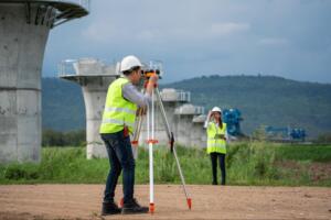
- Fieldwork and measurements – Our crews visit the property, locate existing markers, set new monuments if needed, and collect precise measurements using GPS, total stations, and conventional techniques.
- Calculations and boundary resolution – We analyze the evidence and perform computations that turn field data and record information into a defensible boundary or map.
- Survey drawing and documentation – We prepare a survey plat or report that meets required standards and can be used by lenders, title companies, engineers, or contractors.
- Quality control and sealing – A licensed surveyor reviews the work, confirms it meets state standards, and signs and seals the final document.
Each of these steps represents time, skill, and professional responsibility that explains a large part of your land surveying services cost.
Hidden Work Most Clients Never See

Some of the most important survey work never appears on the surface: chasing down missing records, resolving conflicting descriptions when deeds overlap, coordinating with engineers and title officers, and responding to questions after delivery.
At Southpoint Texas Surveying, we build time for this behind-the-scenes work into our proposals so your project is not disrupted by surprises or disputes.
Typical Price Ranges For Common Survey Types
Because every property and scope is different, responsible surveyors do not quote firm pricing without a basic review. Below are common categories that influence what your land surveying services cost will look like.
Boundary And Lot Surveys For Homebuyers And Sellers
For most homebuyers and sellers in South Texas, the most common request is a boundary or lot survey involving confirming lot limits, showing improvements, and identifying encroachments that could impact a closing.
Costs depend on lot size, shape, ease of access, and how complete existing records are. A standard city lot in a platted subdivision is usually more straightforward than a large, irregular tract divided several times over the years.
ALTA/NSPS And Commercial Surveys
ALTA/NSPS Land Title Surveys involve higher standards and more detailed reporting. Lenders and title insurers use these surveys to issue coverage for larger transactions.
These projects typically cover larger tracts, require additional items such as detailed easement plotting and zoning data, and involve more coordination with attorneys and lenders. The land surveying services cost for ALTA/NSPS work is typically higher and influenced by how many optional items are requested.
Topographic, Construction, And Elevation Certificates
Some projects focus less on ownership lines and more on how the land can be used. Topographic surveys support design work, construction surveys guide foundations and utilities, and elevation certificates document the vertical relationship of structures to floodplain data.
The cost depends on the area size, detail level requested, and how many site visits are needed.
Key Factors That Drive Land Surveying Costs Up Or Down
Two properties on the same street can have very different survey fees. Understanding what drives those differences helps you budget realistically.
Property Size, Shape, And Terrain
The amount of ground to be covered is one of the most obvious factors in land surveying services cost. Larger tracts require more time, irregular lots add complexity, and challenging terrain like steep slopes or dense brush takes more time and specialized equipment.
In South Texas, a compact residential lot will usually be more efficient to survey than a long, narrow rural tract with limited access.
Title Issues, Easements, And Old Records
Surveyors rely heavily on recorded documents. Costs increase when deeds contain vague descriptions, there are unrecorded divisions, numerous easements must be plotted, or older plats need piecing together.
Additional research is an investment in getting boundaries right and avoiding disputes.
Access, Vegetation, And Improvements On Site
A property that is easy to reach and walk is more economical to survey. Work takes longer when gates are locked, thick brush slows line clearing, or structures block measurement paths.
Letting your surveyor know about access constraints ahead of time helps plan the right crew and equipment.
Timeline, Rush Requests, And Market Conditions
Short notice requests may require overtime or schedule changes. Periods of high construction activity can tighten schedules throughout South Texas. More flexible timelines often give room to sequence work efficiently, which can help control cost.
We always encourage clients to involve a surveyor as early as possible.
How To Read A Land Survey Estimate Or Proposal
A clear estimate should help you see where your money is going and what you will receive in return.
Common Line Items And What They Mean
Most survey proposals include: records research covering document review time, fieldwork covering crew time on site, office calculations and drafting including boundary analysis and final drawings, and staking or marking if you have requested visible markers.
If any line item is unclear, ask. A good estimate should be explainable in plain language.
Understanding Hourly Versus Flat Fees
Surveyors use different pricing approaches. Flat fees are common for straightforward work when scope and conditions are well understood. Hourly or time and materials pricing is more typical when title issues or access conditions are unpredictable. Sometimes we use a blended approach.
Red Flags To Watch For In Low Or High Bids
Be cautious when a bid is significantly lower but does not spell out scope or standards, the proposal does not specify survey type, or there is no mention of research or post-survey support.
We recommend asking each surveyor to explain how they arrived at their fee. This conversation can be as important as the number itself.
Ways To Control Land Survey Costs Without Cutting Corners

You cannot change property size or rewrite old deeds, but there are practical steps to keep survey costs reasonable.
Information To Prepare Before You Call A Surveyor
Helpful items include: a copy of your deed, prior survey, or title commitment; any subdivision plat or site plan; details about why you need the survey; and notes about access or known disputes.
Providing this information early reduces back and forth and helps us match the right service to your situation.
Choosing The Right Type And Scope Of Survey
Ordering more work than needed increases land surveying services cost without adding value. Ordering less can lead to disputes or delays. A basic boundary survey may suffice for a fence project, while an ALTA/NSPS survey may be necessary for commercial development.
Coordinating With Your Lender, Title Company, Or Builder
Ask your lender or title company what standard they require, share those requirements when requesting a quote, and coordinate timing with deadlines and construction schedules.
When everyone is aligned, we can complete the survey once in the correct format.
South Texas Considerations That Affect Survey Pricing
Local conditions matter. The same survey type elsewhere might not involve the same challenges you see in Cameron County, Hidalgo County, or surrounding areas.
Coastal, Floodplain, And Elevation Issues
In coastal communities and low-lying areas, surveys may need to account for elevation certificates, setbacks from drainage features, and special building requirements in coastal zones. These elements can increase fieldwork time and affect your survey fee.
Rural Ranch Tracts Versus Platted Subdivisions
Platted subdivision lots usually benefit from clear recorded plats and established monuments. Farm and ranch tracts can extend for long distances with older descriptions based on natural features that have changed. Rural work often requires more travel, line clearing, and careful reconciliation of historic records.
Oil, Gas, And Utility Easements In The Region
Many South Texas properties are affected by oil and gas activity or utility corridors. Surveying may involve mapping existing easements, showing surface sites, and coordinating with energy companies. Properly identifying these encumbrances protects your ability to use and develop your land.
Conclusion
When you understand what goes into land surveying services cost, the numbers on an estimate become much less mysterious. Property size, terrain, records, timing, and local South Texas conditions all play a role in the final fee.
Our goal at Southpoint Texas Surveying is to give you clear information so you can make confident decisions. If you are planning a project or preparing for a real estate transaction, contact our team to discuss your property and request a survey proposal that matches your situation.
Land Surveying Services Cost – Frequently Asked Questions
What factors have the biggest impact on land surveying services cost in South Texas?
Land surveying services cost is mainly driven by property size and shape, terrain and vegetation, title and easement complexity, access conditions, and timeline. Local South Texas issues like floodplains, coastal regulations, and utility easements can also increase research and field time.
Why do different surveyors quote such different prices for the same land survey?
Differences usually come from how each surveyor defines the scope. Some proposals include thorough research and post-survey support, while others only cover minimal fieldwork. Always compare the type of survey and what’s explicitly included—not just the bottom-line price.
How can I reduce land surveying services cost without sacrificing quality?
Gather deeds, prior surveys, and title commitments before you call. Explain why you need the survey and clarify access issues. Confirm requirements with your lender or title company so the survey is done once at the correct level of detail.
When should I order an ALTA/NSPS survey instead of a basic boundary survey?
Order an ALTA/NSPS survey for commercial or higher-value transactions where lenders require detailed information on easements, improvements, and zoning. For simple home purchases or fence projects, a standard boundary survey is often sufficient and more economical.