Hiring a land surveyor in South Texas isn’t something most property owners plan for—it usually comes up suddenly, often during a stressful moment like closing on a home, starting a long‑awaited build, or sorting out a boundary concern with a neighbor. When that happens and you begin looking for experienced land survey services in South Texas, the questions can feel overwhelming. What kind of survey do you actually need? Which rules apply to your situation? And how do you know you’re choosing someone you can trust with something as important as your property?
Quick Answer: Before hiring experienced land survey services in South Texas, confirm the surveyor is licensed by the Texas Board of Professional Land Surveying, ask which type of survey fits your need (boundary, mortgage, topographic, ALTA, or elevation certificate), and request a clear written scope, timeline, and fee. For Rio Grande Valley properties, we also recommend choosing a local surveyor familiar with regional flood zones, colonia boundaries, and county recording requirements to avoid costly delays.
At Southpoint Geodetics, LLC, we understand how much is riding on these decisions. We work alongside homeowners, builders, and real estate professionals across the Rio Grande Valley every day, and we’ve seen how the right surveyor can ease the pressure and keep your project moving forward. Here’s what we hope will make the process a little easier before you hire one.
Why Experience Counts in South Texas

Land surveying in Texas goes well beyond measuring lines on a map. Only licensed surveyors may offer professional services, and their work has to follow the standards set by the state licensing board. That means interpreting legal descriptions, locating monuments that have shifted or vanished over decades, and figuring out how one parcel relates to its neighbors—work a qualified professional surveyor must perform or directly oversee.
Properties in the Rio Grande Valley carry layers of history. Original Spanish and Mexican land grants, porciones, older deeds, informal boundary agreements, and aging markers all show up regularly. A seasoned surveyor knows how to reconcile what the records say with what’s actually on the ground, while following the practice standards set by the Texas Board of Professional Engineers and Land Surveyors (TBPELS).
Accuracy beats assumption. Surveyors who have spent years across South Texas tend to spot patterns and potential problems earlier than someone new to the region. For a closer look at why this is worth taking seriously, our article on why smart South Texas buyers never skip a survey goes into more depth.
Common Types of Land Surveys
Not every project needs the same survey, and the confusion usually starts with figuring out which one fits. Below are the surveys property owners ask about most.
Boundary and Residential Surveys
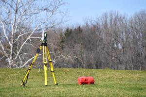
A boundary survey identifies your property lines based on the legal description, recorded plats, and physical evidence on the ground. Depending on the scope, the surveyor may set or restore monuments at the corners or along the lines of the parcel, following the minimum standards for boundary and land title surveys in Texas.
Buying a home, building a fence, or planning an addition? This is usually the survey you need. It clarifies where your land begins and ends, which cuts down on disputes with neighbors. Documents affecting boundaries often have to be prepared or certified by a licensed surveyor before a county will record them.
Our South Texas homeowner’s guide to accurate boundaries is worth reading before any residential project.
Commercial and Development Surveys
Commercial and development work usually calls for more detailed surveying. These projects come with tighter setbacks, shared infrastructure, floodplain considerations, and specific requirements from lenders, title companies, and municipalities.
Topographic surveys map the physical features and contours of a site so engineers and architects can plan for drainage, grading, and construction. ALTA/NSPS Land Title Surveys—prepared under nationally recognized minimum standards—lay out existing improvements, recorded easements, and possible encroachments, and they’re frequently requested during commercial transactions.
Developers and builders also rely on as-built surveys to document completed work, and easement surveys to define access and utility rights. These give project teams the field data they need for planning, design, and permitting.
How Local Knowledge Helps Reduce Risk

We emphasize being a locally owned company that serves the Rio Grande Valley and all of South Texas for a reason. Local knowledge isn’t a slogan—it changes how useful a survey actually is.
Easements and other encumbrances in Texas can arise in several ways, and not all of them show up in a basic title search. A surveyor who knows local records, typical development patterns, and field conditions can flag visible and documented features your title company or attorney should review before they cause delays. Surveyors locate, measure, and report physical and record evidence; questions about title, ownership, or the legal effect of an easement belong to a licensed Texas attorney.
Boundary conflicts come up often. Old fences rarely sit on the legal line, and decades of assumptions about where a boundary runs can lead to disputes. Texas case law recognizes several doctrines that can affect boundaries and possession, which is why property owners frequently bring in both a surveyor and an attorney when conflicts surface. If you’re already in one, our guide on resolving property line conflicts in South Texas explains how a survey supports the documentation your attorney may need.
What to Look for in a Survey Provider
Picking the right surveyor gets easier once you know what to look for. State law sets the framework for who can practice, but a few practical factors stand out to most clients:
-
A Registered Professional Land Surveyor in good standing with TBPELS
-
A track record of projects in South Texas and the Rio Grande Valley
-
Use of both GPS/GNSS technology and conventional surveying techniques
-
Familiarity with the professional rules and standards that apply in Texas
-
Clear communication about scope, schedule, and deliverables
-
Responsiveness that keeps your project on schedule
-
Appropriate professional liability coverage for the work performed
Southpoint Geodetics, LLC was founded by Michael Wood, a Registered Professional Land Surveyor licensed in Texas. We work closely with realtors, mortgage brokers, engineers, and project managers to keep land records accurate and current. Every survey we deliver is signed and sealed by a Texas RPLS under the applicable professional standards. You can explore the full range of services we offer to see how we approach each project, or browse our blog for related topics before reaching out.
Planning Your Survey
Every survey is different. A single residential lot has little in common with thousands of acres or a multi-property corridor, and each survey is scoped around the project and the conditions on the ground.
The work depends on the size of the parcel, the complexity of the boundaries, the condition of records at the county clerk’s office, access to the property, vegetation and terrain, and how much field evidence needs locating. Properties with missing monuments, conflicting calls in older deeds, or unclear chains of title call for more research and verification by a licensed surveyor.
Whether you’re closing on a home in the Rio Grande Valley or starting a development project, bringing in an experienced RPLS early helps surface problems before they get expensive.

Moving Forward with Experienced Land Survey Services in South Texas
When you’re ready to take the next step, contact us to discuss your property. Our team provides experienced land survey services in South Texas, working with you to review your property details, project goals, and any applicable requirements. We will outline the appropriate survey type, explain the scope of work, and identify key considerations based on your site conditions. This approach helps you move forward with a clearer understanding of the process and what your project may require.
What is a land survey and why hire an experienced surveyor in South Texas?
A land survey establishes the boundaries and improvements of your property based on the legal description, recorded plats, and field evidence, using both GPS/GNSS technology and conventional techniques. Under Texas Occupations Code Chapter 1071, professional surveying must be performed by a licensed RPLS. Experienced South Texas surveyors know local records, historical Spanish and Mexican land grants, and field conditions—useful for avoiding boundary disputes and easement conflicts.
What types of surveys does Southpoint Geodetics offer for residential and commercial properties?
Southpoint Geodetics provides boundary surveys for residential properties, topographic surveys for construction planning, ALTA/NSPS Land Title Surveys for commercial transactions, as-built surveys for completed projects, and easement surveys for utility and access rights. We also offer engineering surveys and farm & ranch surveys, all signed and sealed by a Texas RPLS.
What factors affect the complexity of a land survey?
Complexity depends on parcel size, boundary intricacy, condition of existing records, access, and how much field evidence needs to be located. Properties with missing monuments or unclear deeds require more research and verification by a licensed RPLS.
Why is local knowledge important when hiring a surveyor in the Rio Grande Valley?
Local knowledge helps identify easements, encumbrances, and boundary conflicts that don’t show up in a basic title search—especially since Texas recognizes easements created by written instruments, plat dedications, prescription, and implication. Surveyors with South Texas experience know regional patterns, historical property records, and field conditions, which helps prevent disputes.
What should I look for when choosing a land surveyor in South Texas?
Pick a Registered Professional Land Surveyor in good standing with TBPELS, with a proven track record in South Texas and the Rio Grande Valley. Verify their license on the TBPELS website, confirm they use both GPS and conventional surveying techniques, and make sure they communicate clearly about scope and deliverables.
How do I get started with a boundary survey in South Texas?
Contact Southpoint Geodetics directly. We’ll discuss your property, the type of survey that fits your situation, and the specific requirements involved—then provide a customized scope of work for your project.