When a property question pops up, the fastest path to an answer is usually a phone call. Whether you’re closing on a home in Harlingen, planning a build near Brownsville, or settling a boundary question on family land, having a reliable land surveyor phone number on hand can save you days of back and forth.
Land surveying is a detail-driven process, and the right contact at a licensed local firm can clarify your options — and your costs — in a single conversation. At Southpoint Geodetics, LLC, we want that first call to be productive, which is why we put together this quick guide on how to reach us, what to say, and what to expect.
Need a land surveyor now? Call Southpoint Geodetics, LLC at (956) 368-5074 or email Info.southpointsurvey@gmail.com. Our office is open Monday through Friday, 8:00 AM to 5:00 PM (closed weekends). One quick call is usually all it takes to confirm your survey type, timeline, and pricing.
Why Calling a Land Surveyor Directly Saves You Time and Money
Email threads can stretch on for days, and online forms often sit in queues. A direct phone call lets us ask the right follow up questions, gauge the urgency of your project, and give you a realistic sense of timing on the spot.
For real estate deals with tight closing dates, that conversation can prevent costly delays. We can often tell you within minutes whether you need a boundary survey, a mortgage survey, or an elevation certificate, which means fewer surprises and a clearer path forward.

What Is Land Surveying — and Why Is It Essential for Your Property?
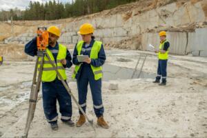
Land surveying is the science of measuring, mapping, and defining the boundaries of real property. A Registered Professional Land Surveyor (RPLS), licensed by the Texas Board of Professional Engineers and Land Surveyors, uses a combination of legal research, field measurement, and precise calculation to produce a legally recognized document that tells you — and everyone else — exactly where your property begins and ends.
At Southpoint Geodetics, LLC, with over 20 years of experience surveying across South Texas, we pair deep knowledge of local land records and original Spanish land grants with state-of-the-art equipment, including robotic total stations and survey-grade GPS technology, to deliver accurate surveying solutions our clients can rely on.
Whether your project involves a single residential lot or a large-scale land development, the foundation is always the same: reliable data and a signed, sealed survey from a licensed professional bound by the Texas Professional Land Surveying Practices Act. Understanding this process helps you ask better questions when you pick up the phone — and helps us serve you more efficiently from the very first call.
What to Have Ready Before You Pick Up the Phone
A short call goes a lot further when you have a few details in front of you. Before dialing, gather any paperwork related to the property and jot down the questions weighing on you. The more specific you can be, the more accurate our initial guidance will be.
Property Address, Legal Description, and Deed Details
The property address is a starting point, but the legal description from your deed is what we truly rely on. Lot and block numbers, subdivision name, county records, and any prior survey documents help us understand the parcel quickly.
If you have a title commitment, plat, or previous survey PDF, mention it during the call so we can factor it into the scope and price.

Key Questions to Ask When You Call a Land Surveyor
A short list of questions helps you compare quotes fairly and avoid misunderstandings later. Consider asking:
-
Which type of survey does my situation actually require?
-
What is the typical turnaround time for this project?
-
Are travel, recording fees, or monument setting included in the quote?
-
Will I receive a stamped, sealed copy for my lender or title company?
Clear answers up front mean fewer change orders and a smoother experience from contract to delivery.
Common Reasons South Texas Property Owners Call a Surveyor
Across the Rio Grande Valley and the wider South Texas region, the reasons people reach out tend to repeat. Buyers and sellers often need a mortgage or boundary survey before closing.
Builders request foundation, topographic, or as built surveys for new construction. Farm and ranch owners call about acreage verification, fence line questions, or splitting parcels for family members.
We also hear from neighbors trying to resolve encroachments before they turn into legal disputes. You can read more about how and the situations we see most often.
How to Verify You’re Calling a Licensed, Local Surveyor
Anyone can list a phone number online, but only a Registered Professional Land Surveyor (RPLS) can legally sign and seal a survey in Texas. Before you commit, confirm the firm holds an active Texas license in good standing and has documented experience in your county. Ask where the office is based, who will be on site, and whether the surveyor is familiar with local plat records filed with the county clerk.
Local knowledge matters in places like Cameron, Hidalgo, and Willacy counties, where FEMA-designated flood zones, colonias, and older subdivisions can complicate even a routine survey. With decades of combined field experience across the Rio Grande Valley, our licensed team understands the regional quirks that out-of-area firms often miss. You can explore the full range of services we offer to see how we support projects throughout the Valley.

What’s the Difference Between a Survey and a Boundary Survey?
The word “survey” is an umbrella term that covers dozens of distinct deliverables, which is one reason calling us directly helps clarify your scope of project before any work begins.
A boundary survey is the most common type — it establishes or reconfirms the legal corners and lines of a parcel based on recorded deeds, plats, and field measurements. It is what most lenders, title companies, and attorneys mean when they ask for a survey in connection with a real estate closing.
A title survey (sometimes called an ALTA/NSPS Land Title Survey) goes further: it combines boundary work with a detailed review of title exceptions, easements, and encroachments, and meets national standards set by the NSPS Land Title Survey specifications — making it the standard for commercial transactions and land planning projects.
Other common types include topographic surveys, which capture elevation and surface features for engineering or construction; elevation certificates for flood zone determinations; and as-built surveys that document what was actually constructed on a site. Knowing which type you need before you call will help you get a faster, more accurate quote.
What Happens After You Call: A Step-by-Step Overview
Knowing what to expect after you dial can make the entire experience feel less uncertain. Here’s how a typical project moves from that first phone conversation to a finished survey in your hands:
-
Initial phone consultation. We ask about the property location, the purpose of the survey, and any deadlines tied to your closing or construction schedule. This call usually takes 10–15 minutes.
-
Quote and scope confirmation. Based on your details, we provide a written quote that outlines the scope of project, including field work, research, monument setting, and deliverables. We make sure you understand exactly what is — and isn’t — included.
-
Title and records research. Before our crew sets foot on the property, we research county plat records, deeds, and any prior surveys to understand the parcel’s history. This step is critical in South Texas, where older subdivisions and colonia lots often carry complex title histories.
-
Field work with advanced technology. Our licensed surveyors visit the site using state-of-the-art equipment — including robotic total stations and GPS instruments — to measure boundaries, locate monuments, and gather the data needed for your specific survey type.
-
Map preparation and review. Our team drafts the survey drawing, applies the licensed surveyor’s seal, and reviews every detail for accuracy before releasing the final document.
-
Delivery to you and your team. We provide stamped, sealed copies in the formats your lender, title company, or attorney requires, and we remain available to answer follow-up questions.
Ready to get started? Contact our team directly at (956) 368-5074 and we’ll walk you through step one right away.

Conclusion
A clear land surveyor phone number, paired with the right information, turns a stressful property question into a manageable next step. When you’re ready, reach out to our team by phone at (956) 368-5074 or email us at Info.southpointsurvey@gmail.com. Our office is open Monday through Friday, 8am – 5pm (closed weekends). You can also connect with us on social media or browse our blog for related topics to keep learning at your own pace.
Why should I call a land surveyor directly instead of using email or online forms?
Calling a land surveyor directly saves time and money. Phone conversations let surveyors ask follow-up questions, assess project urgency, and provide immediate guidance on whether you need a boundary survey, mortgage survey, or elevation certificate—preventing costly delays on real estate deals.
What information should I have ready before calling a land surveyor phone number?
Prepare your property address, legal description from your deed, lot and block numbers, subdivision name, and any prior survey documents. Having this information ready ensures the surveyor can give accurate initial guidance and help determine the scope and cost of your survey project.
What types of surveys do land surveyors offer?
Land surveyors offer boundary surveys, mortgage surveys, elevation certificates, topographic surveys, foundation surveys, as-built surveys, and ALTA/NSPS surveys. The type you need depends on whether you’re buying, selling, building, or resolving property disputes in areas like Brownsville and the Rio Grande Valley.
How do I verify that a land surveyor is licensed and qualified?
Confirm the firm holds an active Texas license as a Registered Professional Land Surveyor and has experience in your county. Ask about their office location, on-site personnel, and familiarity with local plat records, especially important in flood zones and older subdivisions in Cameron, Hidalgo, and Willacy counties.
What questions should I ask when calling a surveyor for a quote?
Ask which survey type you need, typical turnaround time, whether travel and recording fees are included, and if you’ll receive a stamped, sealed copy for your lender. Clear answers upfront prevent misunderstandings, avoid change orders, and ensure a smoother experience from contract to delivery.
Why is a land survey required before buying or selling property?
Land surveys are often required by lenders, title companies, and real estate agents to establish precise property boundaries and prevent disputes. Surveys verify accurate measurements, protect both buyer and seller, and prevent costly legal issues over boundary encroachments or property discrepancies.